Whitehorse, Yukon Territory...I did learn the difference between a Canadian Province and a Territory- (Alberta, British Columbia, etc. are Provinces). A province is not supported by the government to the degree a territory is. The Yukon and Northwest Territories are larger hunks of land with fewer people and therefore need addl assistance to maintain infrastructures. Whitehorse is the capital of the Yukon. Decent size town with a Walmart. I had dinner last night at the Yukon Mining Co restaurant....fresh trout...delicious. I also found the Yukon Brewing company. They only sell beer in growlers, so of course I had to get one. Their summer beer is Birch and they actually tap birch trees and add some of the sap to the beer. Very good....their motto is "beer worth freezing for"...gotta admit, that's pretty good. The RV park I'm at is nothing special...all rigs are just lined up, but I have wifi, satellite TV, and full hook ups for 26$...no complaints. I visited museums and main street today and also took the 2 hour boat ride on the Yukon River. This is a huge river and played an essential role during the building of the Alaska Highway. There is still ice and snow in the river...folks here are wearing shorts, tank tops, etc. cuz it's finally in the 70's. The population is extremly varied. Many, many native indians/eskimos - they are called First Nation people and there are many tribes. I cannot spell nor pronounce any of them. I'm surprised at how many senior citizens are here - no, not RVers, residents.
Tomorrow I'm heading thru the last stretch of the Alaska Highway and hope to cross into Alaska late Monday or Tuesday. This part of the highway has the most severe frost heaves so it will be slow going.
Saturday, June 6, 2009
Friday, June 5, 2009
Friday, June 5th

From Wed - Fort Nelson to Laird River.
Caribou

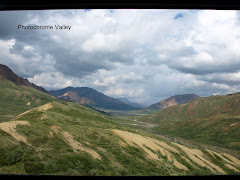
Muncho Lake...turquoise...beautiful!


First black bear, not a great shot - better one on Thursday
I'll post more this evening. I'm in Whitehorse, Yukon. Got here early and I've been washing the trailer and truck and clothes. I've also been crawling under the trailer to look for any issues, but all seems ok. Then I washed ME....on my way to see the sites in Whitehorse....later
Thursday, June 4, 2009
Thursday, 6-4
I'm in Teslin, Yukon, camped on Nistulin Bay. The truck and trailer are filthy. Two several mile long construction areas today (one yesterday)....they water it down which makes mud and gets everywhere. Mud flaps on the truck help, but still it's a mess. Whitehorse, capital of the Yukon Territory is only 111 miles away so I'll be there early tomorrow I hope. This is a real city - population of 24,000. Staying at the Pioneer RV Park which has a RV wash, and will I use it. There is also the Yukon Brewery...no need to say more, huh! I'm staying in Whitehorse until Sunday - need to refresh and regroup before heading out for the last stretch to the border of the US of A again. Once I leave Whitehorse, the Alaska Highway is the worst for frost heaves. It will be a slow go, I'm sure. I'll get updated info in Whitehorse. I'd like to be in Tok Alaska by Monday night and in Anchorage by Thursday. Once in Tok, Alaska, I head south on the Glenn Highway. Anchorage is 328 miles south of Tok. Follows Wrangell-St. Elias National Park which is the largest park in the USA.
I have Wifi here in Teslin which is surprising - not strong enough to download anything...I tried.
Animal sightings....very, very cool!!!
I saw a black bear yesterday, and one today. Caribou, Moose and Stone Sheep yesterday also. And today...a momma grizzly and 2 cubs. Yes, I got pictures. I took them quick of the grizzly - she was busy eating and I kept the truck between her and I. I'll post to my blog this weekend. Also saw Bison, but could not get a picture. That wildfire near Laird River where I camped last night has grown. I left early this morning and they had pilot cars taking folks on the Alaska Highway, both directions. Here in Teslin, I heard they closed the highway for several miles late this morning. As I drove thru it this morning, you could see trees burning. The forest is right along the highway. In some areas, it has been cut down/back for maybe 20 to 40 feet from the highway. Sure glad I got an early start or I'd be stuck a couple hundred miles south.
Just tried to download a photo, but it won't go thru. There will be a bunch for you to view once I can get decent wifi.
All is good.
Wednesday, 6-3
Wow…what a day!
Saw my first black bear and got a picture. Then an Caribou, Moose and Stone Sheep. The sheep are all along the highway. You can stop and watch them, but if you step out of your vehicle, they take off.
I’m in Laird River – not a town, just a lodge with a campground, restaurant, small (very) store, gas and diesel. And they can charge anything they want….how about 1.58 a liter for gas. Really, highway robbery, but no other choice. There is a wild fire about 15 km north of here. They have been fighting it since Monday. The fire fighters are here at the lodge so if an evacuation is necessary, I’ll be one of the first to know. I did not unhook, so I can be outta here pretty quick.
The scenery today was magnificent. The Canadian Rockies are indescribable. I thought the Rocky Mts in Colorado were extraordinary – well, these are better. I’m hoping the photos will give you some idea.
I have not had cell service since Dawson Creek – not real comfortable traveling w/o it, but despite some rough road, slow speeds and construction, it was a good day. The construction was about a ¼ long…thru mud and gravel – thank heavens for 4x4….last thing I wanted to do was get bogged down in mud. Made for a very dirty trailer and truck. I hosed off both earlier today when I get here.
Should make it to Teslin, Yukon tomorrow. A bit more civilization.
Many, many of the one stop places have closed up. Sad, really – but like I’ve been saying, there are not a lot of folks on the road. I know I spend over an hour at a time w/o seeing one other vehicle. Allowed me to stop in the middle of the highway and take photos….one small advantage to no traffic. Will post again and add pictures when I can
Tuesday, June 2, 2009
Tuesday, June 2nd
Nice day and good drive. No issues at all. Road is all paved but there are areas of patches that are pretty rough. I'm in Fort Nelson, BC. Tomorrow with be a short drive day so I can stay at Muncho Lake...this lake is turquoise due to copper runoff. Supposed to be quite amazing. There is a provencial campground on the lake and I'd like to get as close to the lake as I can, for the day/night. Dry camping, no wifi, or any hookups so that means no postings from me until Thursday.
I am amazed at how "empty" the Alaska Highway is.....not many travelers at all. There are long periods of time when I feel I am the only one traveling on it. And yet, a bunch of RVs have pulled into this place in the last couple of hours. I recognize a few from Dawson Creek. This campground has a saloon and restaurant about 30 feet from my campsite...and of course I had to check it out. I'm an anomoly...traveling solo and being female and old at that. Nice conversation starter with the locals.
Funny story....I was passed by 3 cars with Arizona license plates. Speed limit is 100 km/h - or 60 mph (I'm getting the hang of the meter system)...anyway, I traveled at about 55 cuz I'm not sure of the road conditions and at 55 saves it me a 1 or 2 miles per gallon. They must have been going close to 70. About 50 miles later, I spotted red flashing lights...yup, you guessed it...all 3 were pulled over. No clue what kind of fine they got.
The natural gas line followed most of the 238 miles of the Alaska Highway that I was on today. Many, many dirt turnoffs with signs indicating compressor stations and many different Gas Companies. The smell of natural gas was evident in several areas. AND - I did see a male moose grazing, and a female and baby x'd the Alaska Highway in front of me but there was no time to get a photo. They don't really run, just kinda lumber along - and she made sure she got back in the trees with that baby.
A little history of Fort Nelson. This was the original beginning of the Alaska Highway back in 1942. The US Army had already built a road from Fort St. John (SW of Fort Nelson) to Fort Nelson. Zero was the military post that served as the launch point for road construction north to Whitehorse (Yukon).
Much warmer here and no reason why...elevation is actually a bit higher than Dawson Creek.
I should have much better views of the Canadian Rockies tomorrow, but you'll have to wait until I get wifi again to see the photos.
A few pictures from today:


Monday, June 1, 2009
Monday, June 1
Ok, let's get right to it. I traveled the Alaska Highway for about 16 miles and turned off onto the original Alaska Highway...yeah, it gets confusing.  But compare it to the original route 66 in the states. However, much of the original or Pioneer Road, as it was called, is still driveable at least to Fort Nelson. It was upgraded as soon as 1943. Anyway, there remains, and in very good shape, the only remaining wood bridge still in use. Kiskatinaw Bridge. Very impressive.
 But compare it to the original route 66 in the states. However, much of the original or Pioneer Road, as it was called, is still driveable at least to Fort Nelson. It was upgraded as soon as 1943. Anyway, there remains, and in very good shape, the only remaining wood bridge still in use. Kiskatinaw Bridge. Very impressive.


On a lighter note, I started seeing this sign around Chetwynd (south of Dawson Creek). At first glance, I thought it indicated a mountain range....yeah, yeah...laugh - I sure did. Mountain range yes, but on the road, not scenery. A very important sign along with the red triangles. Just a little humor (very little, I know) 
I must say, these Canadians are sure layed back folks...much different than Americans. Non agressive drivers, everyone appears to say within or under the posted speed limits. Also, no sales tax on anything. I don't know what the % of property or income tax is. I know it's a lot to support their social system. Unemployment in British Columbia is over 13% - mainly due to the forest industry slowing down. Partly due to the lack of new construction but also due to the beetle infestation. It's bad in the US, but here is it much, much worse. Entire mountain sides have been destroyed. Radio is horrible....only a couple stations. One is government owned which is ok, but kinda boring since all it is talk-radio. Music is classic rock...and anything current is, obviously, by Canadian artists. Ice Hockey is huge here, no surprise, huh!!
A bit of good news. My sister will be joining me on June 12th. Her orthopedic doc will read the MRI on 6-9. He's sure she will need arthroscopic surgery, but will give her a cortisone cocktail, a brace, and schedule the procedure for July. A month ago the flights into Fairbanks were much less than those into Anchorage. Now, it's the opposite (Mike...you might want to check flights for your trip). A minor change to my tentative itinerary. I'll head to Anchorage instead of Fairbanks; meet my sister and we will go from there. She will stay and travel back to Colorado with me (via Alberta Canada). Her son is salmon fishing out of Homer for the summer. His first trip out on his assigned boat brought in 27,000 pounds of sock-eye salmon. We will try and coordinate seeing him depending on his schedule. Plus we want to take the train trip between Anchorage and Fairbanks, and the tour to the Arctic Circle. For the immediate future, I'm all set to head out tomorrow morning. The plan is to get to Fort Nelson. Tons, and tons of history. I did buy a book, pictorial history of the building of the highway - I'll use it as a guide for the historic stuff. (Kathy...I've started your magnet collection....) Ok, I've rambled on long enough. Thanks to all of you for your encouraging comments - all the comments are most appreciated.
Sunday, May 31, 2009
A day in Dawson Creek
It finally warmed up to about 60 degrees and right now the wind is quiet. It is 7:30pm but the position of the sun indicates, to me, that it should be around 4:00 pm. Currently there is approx. 16 hours of daylight. This will increase as I move north to around 20 hours.
I did meet 2 couples from California heading up the highway. They are not traveling together. Met one couple at the Visitor Center and the other at the RV Park. They are heading out tomorrow while I'm staying until Tuesday. There is a Chevy dealer here so I'm hoping to get my best friend on wheels checked out. Will get the tires rotated and balanced also. I'm sure I'll meet up with these folks later in the week, and that will be nice.
Per the folks at the Visitor Center, the highway is in pretty good shape. Worst part is at Destruction Bay - about 10 miles of very rough road. Destruction Bay is in northern Yukon between Haines Junction and Beaver Creek. Very important to adhere to all the flags and speed limit signs - which I have been doing.
No cable TV service here at this RV park. I did rent a couple of movies so I think I'll head over to the TV room and watch them....Later.
More photos....


Famous Signs:


Famous Signs:


Subscribe to:
Posts (Atom)
